Severe

Here are a few supplemental links to get all local warning, watch, and advisory details from our local NWS offices: weather.gov/jax/, weather.gov/tae/, weather.gov/tbw/.

Latest Information Below Via Storm Prediction Center

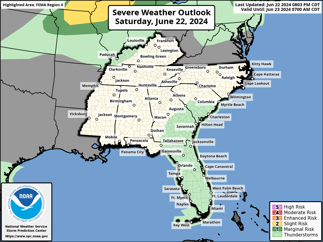
Day 1 Convective Outlook:

The Day 1 Severe Weather Outlook for the Southeastern United States from the Storm Prediction Center. Go to spc.noaa.gov for the latest information and more details.

Day 2 Convective Outlook:

The Day 2 Severe Weather Outlook for the Southeastern United States from the Storm Prediction Center. Go to spc.noaa.gov for the latest information and more details.

Day 3 Convective Outlook:

The Day 3 Severe Weather Outlook for the Southeastern United States from the Storm Prediction Center. Go to spc.noaa.gov for the latest information and more details.

Additional Convective Outlooks:
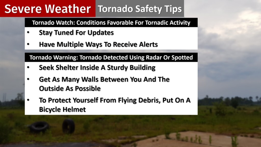
Severe weather outlooks for days 4-8 for the lower 48 states from the Storm Prediction Center. Go to spc.noaa.gov for the latest information and more details.

Tornado Safety:

The difference between a Tornado Watch and Tornado Warning is explained and tips for each are given. In a Tornado Watch, stay tuned for the latest updates and have multiple ways to receive alerts/warnings. A Tornado Warning means a tornado has actually been detected using radar or spotted. Take action immediately by getting into an interior room of a sturdy building.

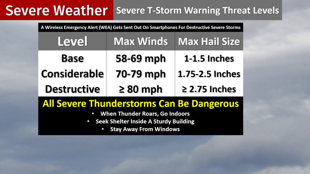
Severe T-Storm Warning Threat Level Breakdown:

There are three different threat levels for severe thunderstorm warnings. The highest is the destructive level and triggers a Wireless Emergency Alert (WEA) on smartphones as either winds of 80 mph are possible and/or occurring or hail could be/is 2.75 inches in diameter or larger. Also, remember that all severe t-storms/any t-storm can be dangerous.

Today’s Storm Reports (24 Hour Period Starts At 8AM EDT/7AM EST):

Filtered storm reports via the Storm Prediction Center. Go to spc.noaa.gov for the latest information and more details.

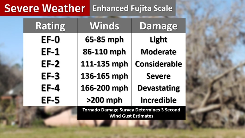
Enhanced Fujita Tornado Damage Scale:

The scale goes from an EF-0 rating (65-85 mph wind estimates) for light damage through EF-5 (wind estimates over 200 mph) for incredible damage. Each 0-5 rating with wind estimates and a damage description is noted. 1 = 86-110 mph & Moderate Damage/2 = 111-135 mph & Considerable Damage/3 = 136-165 mph & Severe Damage/4 = 166-200 mph & Devastating Damage

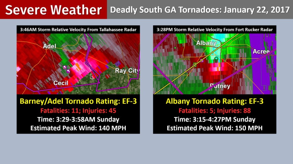
2017’s Deadly South Georgia Tornadoes:

Two EF-3 tornadoes that struck in South Georgia on Sunday, January 22nd, 2017 are described with storm relative velocity radar images shown. The one that hit the Barney/Adel area in the overnight hours (3:29-3:58AM) killed 11 and injured 45. It had an estimated peak wind of 140 mph. The Albany one hit in the middle to late afternoon (3:15-4:27PM) and killed 5. 88 additional injuries occurred. The estimated peak wind was 150 mph.

February 2024 Bradford County Hail: