

Tropical Storm Eta is weakening some more as it moves closer to North Central Florida. The 1AM advisory put Eta’s center about 35 miles southwest of Cedar Key. Maximum sustained winds had fallen to 60 mph.
NHC Advisory & Forecast Track:

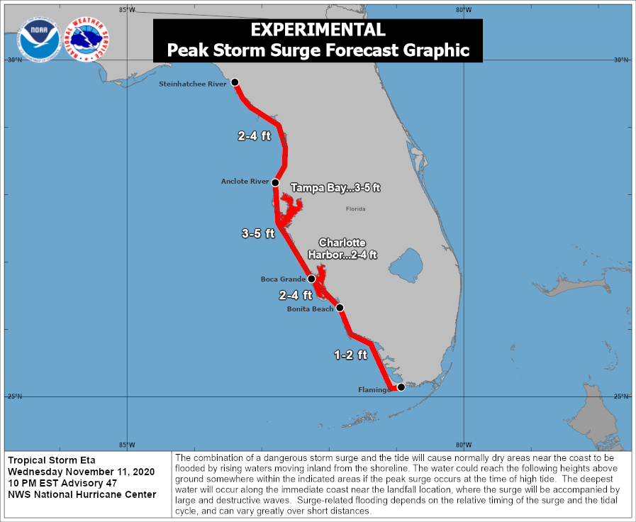
A Storm Surge Warning remains in effect from Bonita Beach to the Suwannee River. A Storm Surge Watch extends from the Suwannee River to the Steinhatchee River. While values 3 to 5 feet above ground are not extreme, this level of surge was still causing significant issues in the vulnerable Tampa Bay area. Around Cedar Key, wind direction will be critical in determining peak surge values.
NHC Storm Surge Expectations:
Locally, parts or all of Alachua, Baker, Bradford, Camden, Clay, Columbia, Duval, Flagler, Gilchrist, Levy, Marion, Nassau, Putnam, St. Johns, and Union counties are under a Tropical Storm Warning. Coastal Dixie and Taylor counties are covered by a Tropical Storm Watch. Widespread power outages are not expected. However, if you are in one of these zones, it may not be a bad idea to charge up your devices as a precautionary measure. While some schools will still be open, classes will not be in session for many North Central and Northeast Florida students on Thursday.
Flash flooding has been an issue with Eta for areas further to our south in Florida and Central America. However, the flood risk is lower across North Florida and South Georgia. Much of the rain should stay south of Gainesville and St. Augustine.
2 Day Rainfall Forecast:

An isolated tornado cannot be completely ruled out in the Jacksonville/Gainesville area, but chances are low.
Live coverage begins at about 2AM on Facebook, Twitter, and YouTube. For Eta’s latest forecast track, go to cloudsweather.com/tropics. For local radar, head to cloudsweather.com/radars. The latest Tallahassee and Jacksonville County Warning Area alerts can be viewed @clouds_wx on Twitter.