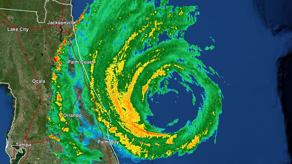
Tracking Hurricane Isaias

Category 1 Hurricane Isaias is continuing to impact parts of the Bahamas. As it gets closer to Florida, the hurricane is expected to turn to the north. Isaias’s exact track will determine what type of impacts the Florida Peninsula and Southeast Georgia receive. A Hurricane Warning is in effect from Boca Raton to the Flagler-Volusia County line. In our coverage area, Coastal St. Johns and Flagler counties are under a Tropical Storm Watch and Storm Surge Watch.

Tropics Become Very Active as Two Systems Threaten United States

Hanna continues to strengthen as it moves toward the Texas coast. Maximum sustained winds have increased to near 65 mph. A Hurricane Warning is in effect from Port Mansfield to Mesquite Bay. A Saturday PM landfall is expected to occur south of Corpus Christi.

In the Central Pacific, Major Hurricane Douglas is tracking toward Hawaii. A Hurricane Watch includes Honolulu, Maui, and the Big Island.

Tracking Dorian

Hurricane Dorian continues to be monitored very closely. It devastated parts of the Bahamas. When it made landfall on Great Abaco Island (near Marsh Harbour) with 185 mph maximum sustained winds, it tied the 1935 Labor Day Hurricane for the strongest Atlantic hurricane landfall on record. Catastrophic storm surge also occurred. For the first time in recorded history, at least one Category 5 hurricane has now occurred in the Atlantic Basin for four consecutive years.

This storm is expected to track off to the east of North Florida and South Georgia. A Hurricane Warning remains in effect from Sebastian Inlet to Ponte Vedra Beach. A Hurricane Watch and Tropical Storm Warning covers our coastal communities to the north. The greatest impacts will be in coastal areas. Storm surge looks to be the biggest threat with heights 3 to 5 feet above ground forecast in some spots. Hurricane-force wind gusts, flash flooding, and isolated tornadoes are the other noteworthy hazards.

Watching Dorian Carefully

As Dorian causes conditions to deteriorate in the Windward Islands tonight, concern is increasing across the Southeast about potential impacts from this system over Labor Day weekend. While confidence is low about that part of the forecast, it does appear some direct impacts will occur in Puerto Rico midweek. They are especially vulnerable as recovery from Hurricane Maria continues. As of this post, a Tropical Storm Watch was in effect there.

Parts of North Florida Remain Under Flood Watch

A Flood Watch continues for areas around Gainesville and Perry. Since Thursday, at least one weather station in Dixie County has picked up over a foot of rain. Concentrated heavier rainfall had struggled to reach inland communities. Model data is having a tough time figuring out exactly how this situation will evolve. However, as of 8AM Saturday, rainfall was spreading across at least some more of North Central Florida.